

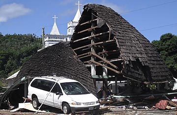
A destroyed structure is seen among debris near a church in the village of Leone, American Samoa
Early in the morning on Sept. 29, an earthquake deep under the Pacific caused a massive tsunami that devastated the islands of Samoa and American Samoa, killing 111 people, ravaging villages and flattening homes. The earthquake struck at 6:48 a.m. and measured 8.3 on the Richter scale. By 7:04 a.m., an emergency alert went out from the Tsunami Warning System, a global network of sensors monitored by scientists. Less than 10 minutes later, the tsunami, with waves measuring nearly 15 ft. high, hit land.
Bad as the damage was, it could have been much worse. Laura Kong, head of the International Tsunami Information Center in Hawaii, says Independent Samoa had run a tsunami drill with planned evacuation routes in October 2007 and again last year. The preparation saved countless lives during this week's disaster.
When it comes to surviving a tsunami, every preparation — and every second — counts. In 2004 an earthquake off the coast of Indonesia launched the massive Indian Ocean Tsunami, which killed more than 230,000 people. While the Pacific has had a Tsunami Warning System in place since 1965, it was only after that disaster that Indian Ocean nations developed one of their own. As many as 95% of tsunamis are local, Kong says, striking within an hour of the earthquake — the 2004 disaster included. That time frame gives community members little time to react — even if they are aware of the danger.
The Pacific's Tsunami Warning System is jointly operated by three control centers, in Japan, Alaska and Hawaii, where it has its headquarters. It uses earthquake information from seismic stations that are part of the Global Seismic Network overseen by the U.S. National Science Foundation and the U.S. Geological Survey, with contributing instruments, data and cash from countries around the world. The centers can cost hundreds of millions of dollars just to implement, Kong says, with the money coming from the countries that support each center as well as from donors like the Red Cross and U.N. organizations. When an earthquake strikes, the system analyzes its location and magnitude. If the quake fits the parameters for tsunami-like conditions, a warning is issued to each country within range of danger. The warning often includes likely arrival times for coastal communities.
Once the warning is sent to local governments, however, the safety of citizens at risk often depends on how advanced the infrastructure in each country is. Developing nations may lack the communications system to get the word out effectively. "Some countries have the infrastructure already," Kong says, "some countries are developing it, and some countries may never have it."
People like Brian Carlson, IT director for humanitarian and emergency affairs at World Vision, are working on technology to improve such early-warning infrastructure. Carlson, who traveled to India shortly after the 2004 tsunami, said he noticed two communities just miles apart: one was full of survivors, while the other was wiped out entirely. The reason for that difference was that the surviving village was notified by a family related to a man in Singapore who saw the tsunami warning on TV and called his family. "It was a simple phone call on a cell phone that saved hundreds of people," Carlson says. He now works on researching technology to improve disaster response as a whole. "It's literally word of mouth right now," Carlson says. If coastal residents don't know a tsunami is on the way, "they find out as soon as the wave makes landfall."