
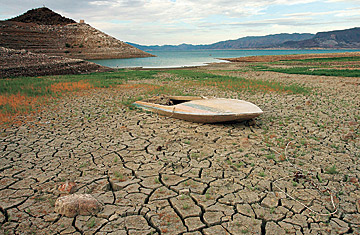
A prolonged drought-and increasing demand-has left Lake Mead well below capacity.
There is no shortage of ways to see just how short of water Lake Mead is. You can count the white bathtub rings of mineral deposits on the bedrock walls of the sprawling, 250-sq.-mi. (647 sq km) reservoir, indicating the old high-water mark--now left nakedly exposed 100 ft. up. You can look at the docks that have been moved repeatedly, chasing the receding lake. Or you can simply read a line graph at the reservoir's visitor center, which tracks the water elevation of Lake Mead since it was created by the construction of the Hoover Dam in 1935. After years of...
To continue reading:
or
Log-In

