

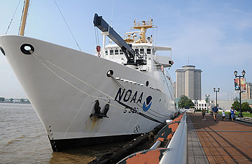
The NOAA Thomas Jefferson sits at port on the Mississippi River in New Orleans, May 31, 2010.
Give the image makers at BP credit for knowing how to stick to a story. If you had (a) been spilling oil into the Gulf of Mexico at a rate of up to 25,000 bbls. per day since April 20, and (b) been spraying dispersants on it to keep much of it from floating to the surface, you'd find it hard to say "who me?" if scientists began finding huge plumes of oil drifting in underwater currents.
But that's been BP's position. Not only has the oil giant not been willing to take the blame for the toxic clouds below the waves, it's denied they even exist. Today, however, scientists from the National Oceanic and Atmospheric Administration (NOAA) announced that they had found the smoking gun that most everyone else believed was there in the first place.
It was on May 30 that Tony Hayward, BP's CEO and in-house gaffe machine, first went on the record denying that any hidden oil plumes were swirling through the Gulf. "The oil is on the surface," he said. "There aren't any plumes." But that could be true only if some basic rules of chemistry and arithmetic had been repealed.
As of last week, BP had sprayed 830,000 gal. of the dispersant Corexit on the surface of the Gulf and into the busted wellhead. The chemical causes oil to break apart and drop to mid-depths, where it's free to float where the currents carry it. Given the rate at which oil has been spilling since April 20, the 250,000 bbl. estimated to be on the surface of the Gulf cannot possibly account for all that's been leaked, even if you include what's been burned off or has evaporated away on its own.
Two days before Hayward's remark, scientists from the University of South Florida (USF), aboard the school's WeatherBird II survey ship, found a six-mi. (9.6 km) wide, 22-mi. (35.4 km) long plume 20 miles (32 km) northeast of the site of the wrecked oil rig. Just as the chemical models said dispersed oil should behave, the plume was floating 3,300 ft. (1 km) below the surface. One other plume in another location had previously been spotted by other observers. In an abundance of caution, the USF team would not say that the new formation definitely belonged to BP; there are an awful lot of messy rigs at work in the Gulf, after all. It would say only that the plumes were not naturally occurring and chemical tests would have to be conducted to confirm their origins. Now those tests are done.
When the WeatherBird II was at sea, USF scientists gathered water samples in one-liter, amber bottles at three different sites and six different depths. Since then, they've been working with NOAA to subject the water to all manner of tests, including gas chromatography and mass spectrometry — which produce a sort of chemical fingerprint of whatever substance is being analyzed. They then compared those analyses to the fingerprint for oil known to come from the BP well. That sealed the deal. At one site 42 miles (68 km) northeast of the well head, the scientists confirmed a chemical match. At a second one nearby, the concentrations of oil in the sample were too low to establish a connection. Only at the third site, 142 mi. (229 km) southeast, did the results put BP in the clear.
"We have always known there is oil under the surface," said NOAA Administrator Jane Lubchenco in an apparent swipe at BP's intransigence. "The questions we are exploring are where it is, in what concentrations, where it is going and what are the consequences for the health of the marine environment."
The report is not entirely without some positive news. For now at least, NOAA says the oil is in "very low concentrations," and with the exception of one sample at one site at a depth of about 1,000 ft (300 m), that concentration drops off the deeper the plume goes. That makes it less likely that much oil can sweep down to the Gulf floor, and that could spare sensitive areas like the DeSoto Canyon, a nutrient-rich trench near the spill site that is a breeding and feeding ground for all manner of life forms.
NOAA plans to keep up its investigations, and even expand their scope. One of the agency's survey vessels, the Thomas Jefferson, is currently conducting expeditions of its own, and another, the Gordon Gunter, has just returned. In addition, a P-3 hurricane-hunting aircraft is flying regular sorties over the Gulf, using new equipment to monitor the loop current — the subsurface flow of water that, it is feared, could catch the oil and carry it around Florida and up the East Coast.
All of this comes on a day that BP is rightly boasting of the nearly 15,000 bbl. of oil its new well cap has succeeded in siphoning up to the surface in just 24 hours, on top of the 11,000 bbls. that were collected the day before. But it also comes at a time that government scientists are growing more convinced than ever that the 25,000 bbl. daily flow rate itself is a lowball figure. Not only may the spill be more than that, they say, it may be "multiples" of that.
"I've said time and time again that nothing good happens when oil is on the water," incident commander Adm. Thad Allen repeated in a press conference on Monday. If nothing else, there's now at least proof of just whose oil much of it is.