

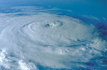
An aerial view of a hurricane
Major anniversaries of natural disasters are usually times to reflect with awe on the forces the planet can unleash — and to acknowledge the human suffering that too often results. The fifth anniversary of Hurricane Katrina's assault on the Gulf Coast, coming up at the end of August, will almost certainly serve as a prime example.
But the coastal states may not have the luxury of looking back at 2005. If a growing number of forecasts are correct, the hurricane season of 2010 could be a monster — one that will have the Eastern states from the Gulf of Mexico to New England fearfully watching the sea all summer.
As recently as a few months ago, storm experts were predicting an average hurricane season this year, or maybe one even a little below average. In a typical year, the Atlantic brews up about six hurricanes. Last year, there were a paltry three. Just in the past week, however, hurricane watchers at universities and private forecasting companies have started to talk about numbers more like seven or eight. On Tuesday, Britain's official weather service — its venerable Met Office — joined the consensus. On Thursday, the U.S. will weigh in, as the National Oceanic and Atmospheric Administration presents its own outlook, and nobody expects it to be any more favorable.
"The 2010 hurricane season is not looking good," says Greg Holland, director of the Earth System Laboratory at the National Center for Atmospheric Research in Boulder, Colo. This year is a lot like 2005, the worst hurricane system on record, he says. "Overall conditions are very similar, with one important difference: they are actually a bit worse."
The conditions that Holland and the others are talking about have mostly to do with the temperature of the ocean. In the eastern Atlantic, the normal spawning grounds of hurricanes that threaten the U.S. and the Caribbean, the waters are the warmest they've been in 50 years — and all other things being equal, warmer surface temperatures mean more, and more powerful, hurricanes.
All other things are not equal, though, and in this case, that's not a good thing. For the past year or so, ocean temperatures in the Eastern Pacific have been elevated thanks to one of the periodic El Niño events that shows up every few years. When El Niño is in full force, it also alters wind patterns halfway around the world, creating something called vertical wind shear — winds blowing at different strengths or directions at different altitudes. That tends to rip hurricanes apart before they can get themselves organized.
The latest El Niño warming is waning faster than expected. That won't do much to help the oceans cool before the hurricane season starts on June 1, but it does eliminate the wind shear that could disrupt the storms. Putting those factors together doesn't guarantee a bad season, but it's about as close as you can get in the uncertain science of long-range forecasting. Still, there are plenty of things about which forecasters won't even hazard a guess. "We don't know exactly how many storms," says Holland, "and we don't know where they will hit." You could have 10 or even 20 major hurricanes, and if they all stay away from land, the damage to life and property could be minimal.
But it would be foolish to bet on nature's being that kind. "We have an enormous number of vulnerable people, plus commerce, industry and everything else along the Gulf and up the East Coast," says Holland, "and more and more people are moving in all the time." Even without the certainty that a major hurricane will strike this year, he says, "we have to be ready for a high level of risk for the entire season."
Lemonick is the senior science writer for Climate Central.