

Van Ness Avenue, San Francisco
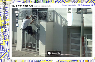
Is that man breaking into an apartment building? Does that tollbooth operator realize she's being photographed? And isn't it illegal to have cameras in New York's Brooklyn Battery tunnel?
Such questions have been raging online in recent weeks, as Google's new" Street View" has sent techies scrambling to browse through the miles and miles of street-level photos now available through Google Maps. But while such blogs as BoingBoing.net and Mashable.com have made something of a joke out of the many humorous (a man apparently caught mid-sneeze), bizarre (the ghost of E.T.?) and lewd (a woman's underwear poking out of her low-riding jeans) images captured by the web giant, privacy concerns have led many watchdog groups to quickly retort that Street View is no laughing matter.
"There is a serious tension here, between the concepts of free speech, and open information, and the idea of privacy," says Kevin Bankston, staff attorney with the Electronic Frontier Foundation." There's definitely a privacy concern that an unmarked Google camera van can, and in fact has, captured images of people, whether in the street or in their homes, in a manner that could be embarrassing or even dangerous to them." He adds: "We don't think what Google's done here is necessarily illegal, though a few images may cross the line and may create liability. It's more that they've done something that's really irresponsible and rude to people."
Google has maintained that these street-view images were captured in broad daylight on public streets — hardly an invasion of privacy. Over several months, Google staff (who took shots in San Francisco), as well as employees of a third-party firm (which did the same in Miami, Denver, New York and Las Vegas), equipped vehicles in select cities with imaging equipment and drove the streets, snapping photos of everything in sight. At maps.google.com, users can drag a human figurine over one of the highlighted streets in those cities, and a window will open that displays the photo taken at that very spot. Users can then grab the image and spin it, turning 360 degrees to get a virtual tour of a given neighborhood, or click on a series of arrows to move up or down the street, one photo at a time.