

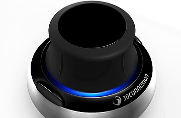
The SpaceNavigator isn't a joystick, nor is it a trackball. It is a wheel, anchored to a rewardingly heavy base, that you twist, tilt, nudge, press and pull to move up, down, forward and back, and also pitch and yaw. (Sorry, aviators: no roll.)
When it came to manipulating Google Earth, I found the SpaceNavigator incredibly useful. When my wife and I were browsing real estate near New York City, we located all of the Metro North train stops out of the city then virtually navigated the route, seeing where each town was in relation to the rest, and comparing relative commutes. A quick lift of the rubber wheel and we get a bird's-eye view; press down again and we're back at street level.
There is a Google Earth plug-in you can download at fboweb.com that shows realtime flight traffic for many airports, and even has an hourly snapshot of all planes currently in the air that have a U.S. departure or arrival. (Once you have Google Earth installed, go to fboweb.com and click on the "Google Earth Primer" button.) It's a dramatic piece of software: there you are, in your own home, and you can monitor planes taking off and landing at LAX, O'Hare or a handful of other impossibly busy airports. The SpaceNavigator improves the experience, by giving you a manageable way to, say, find a particular plane then zoom in and level off next to it, to get a pilot's view of the flightplan.
The annoying thing about the SpaceNavigator is that you can't use it for much else. It comes with a Windows-based photo viewer, so you can more easily scrutinize high-megapixel shots. But as I said it's just a viewer, not an editor, and Photoshop and other leading photo software doesn't support SpaceNavigator at this point. You can't even use it as a mouse replacement, and it isn't yet compatible with Macs, though I assume that will be remedied in the near future. Complaints aside, it's a very well made piece of hardware for the $60 it costs, one whose unique ability to let you move effortlessly through three-dimensional space will no doubt, in time, find countless uses. In the meantime, you've got the Earth.